Changes
On January 11, 2024 at 5:05:55 PM +1100,
-
Updated description of Road Segment Data from Data.NSW from
<p>There have been a number of requests for "State Roads" data. This data is currently available via the Data.NSW Spatial Collaboration Portal.</p> <p>To access Road Segment Data please follow the instructions below;</p> <ol> <li>From <a href="https://portal.spatial.nsw.gov.au/">https://portal.spatial.nsw.gov.au/</a></li> <li>Click the <em>Browse Data</em> tile</li> <li>Click <em>NSW Data themes</em> tile</li> <li>Click the <em>Transport</em> icon</li> <li>Click the link <a href="https://portal.spatial.nsw.gov.au/portal/apps/sites/#/home/items/d05fb8d70c4c42bd859e8b8cae60a387">NSW Transport Theme - Road Name Extent</a></li> </ol> <p><img src="https://opendata.transport.nsw.gov.au/sites/default/files/styles/panopoly_image_original/public/Image%201.png?itok=Zj8I2HTQ&c=57759871b0db5f3b792ed8c6dc3c4669" alt="homepage" /><br /> 6. Click on Export Data (highlighted above)</p> <p><img src="https://opendata.transport.nsw.gov.au/sites/default/files/styles/panopoly_image_original/public/Image%202.png?itok=uy1Gkd3E&c=2f9dc44fee9f3e79d7b5348119a8827f" alt="Export Page" /><br /> 7. <strong>Do you want to select which layers to export?</strong> You can select <em>Yes</em> and choose from the layers provided OR you can select <em>No Thanks. I want to export data from all layers</em>. This will download all data sets. In the example below RoadNameExtent is selected.</p> <p><img src="https://opendata.transport.nsw.gov.au/sites/default/files/styles/panopoly_image_original/public/Image%203.png?itok=DMQQSR4S" alt="Layers to Export Page" /><br /> 8. Click <em>Next</em> ><br /> 9. <strong>Do you want to specify an extent</strong>? Select No or <em>Yes, by drawing the extent on a map</em>. If you select ‘No’ all the data will be extracted. If you wanted to specify an extent of data extraction, e.g. around Sydney in the screenshot below, use the square icon labelled ‘Draw a rectangle’. This will draw a square centred on the point where you clicked on the map. You can change the shape from the icon labelled ‘Reshape’ to get the required area of extraction.</p> <p><img src="https://opendata.transport.nsw.gov.au/sites/default/files/styles/panopoly_image_original/public/Image%204.png?itok=T28ur_3b" alt="Map Selection View" /><br /> 10. Click on <em>Next</em> ><br /> 11. Select your preferred Export format. Please note the limitation of ESRI Shape files truncating attribute names to 10 characters.<br /> 12. Select your preferred Export datum: Please note the current preference of GDA2020, although that depends on your objective.<br /> 13. Select your preferred Export coordinate system: ‘Geographic’ will export the geometries in latitude/longitude. MGAxx coordinate systems will export the geometries in metres.<br /> 14. Type your email address</p> <p><img src="https://opendata.transport.nsw.gov.au/sites/default/files/styles/panopoly_image_original/public/Image%205.png?itok=KQ2XbSQL" alt="Attribute Selection" /><br /> 15. Click <em>Export</em><br /> 16. You should see the screen below</p> <p><img src="https://opendata.transport.nsw.gov.au/sites/default/files/styles/panopoly_image_original/public/Image%206.PNG?itok=4isSITci" alt="Confirmation Screen" /><br /> 17. Check your inbox for an email from Customer Service with a link to download the data.</p>
toThere have been a number of requests for "State Roads" data. This data is currently available via the Data.NSW Spatial Collaboration Portal. To access Road Segment Data please follow the instructions below; 1. From [https://portal.spatial.nsw.gov.au/](https://portal.spatial.nsw.gov.au/) 2. Click the *Browse Data* tile 3. Click *NSW Data themes* tile 4. Click the *Transport* icon 5. Click the link [NSW Transport Theme - Road Name Extent](https://portal.spatial.nsw.gov.au/portal/apps/sites/#/home/items/d05fb8d70c4c42bd859e8b8cae60a387) 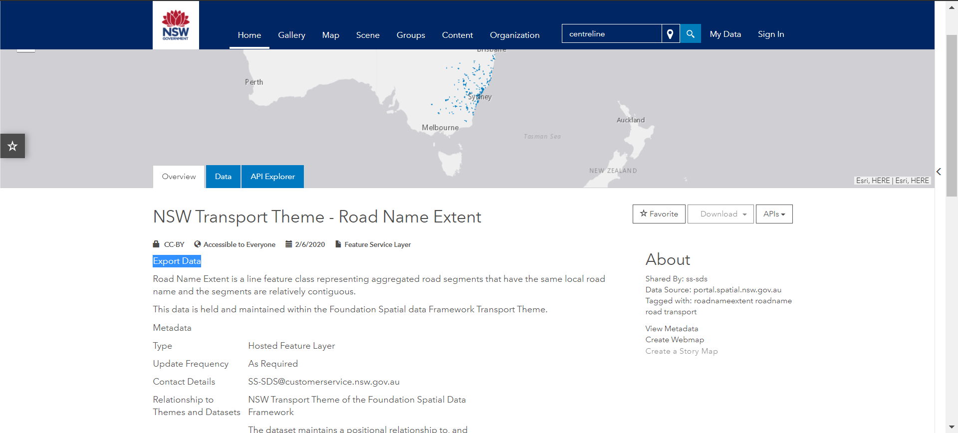 6. Click on Export Data (highlighted above) 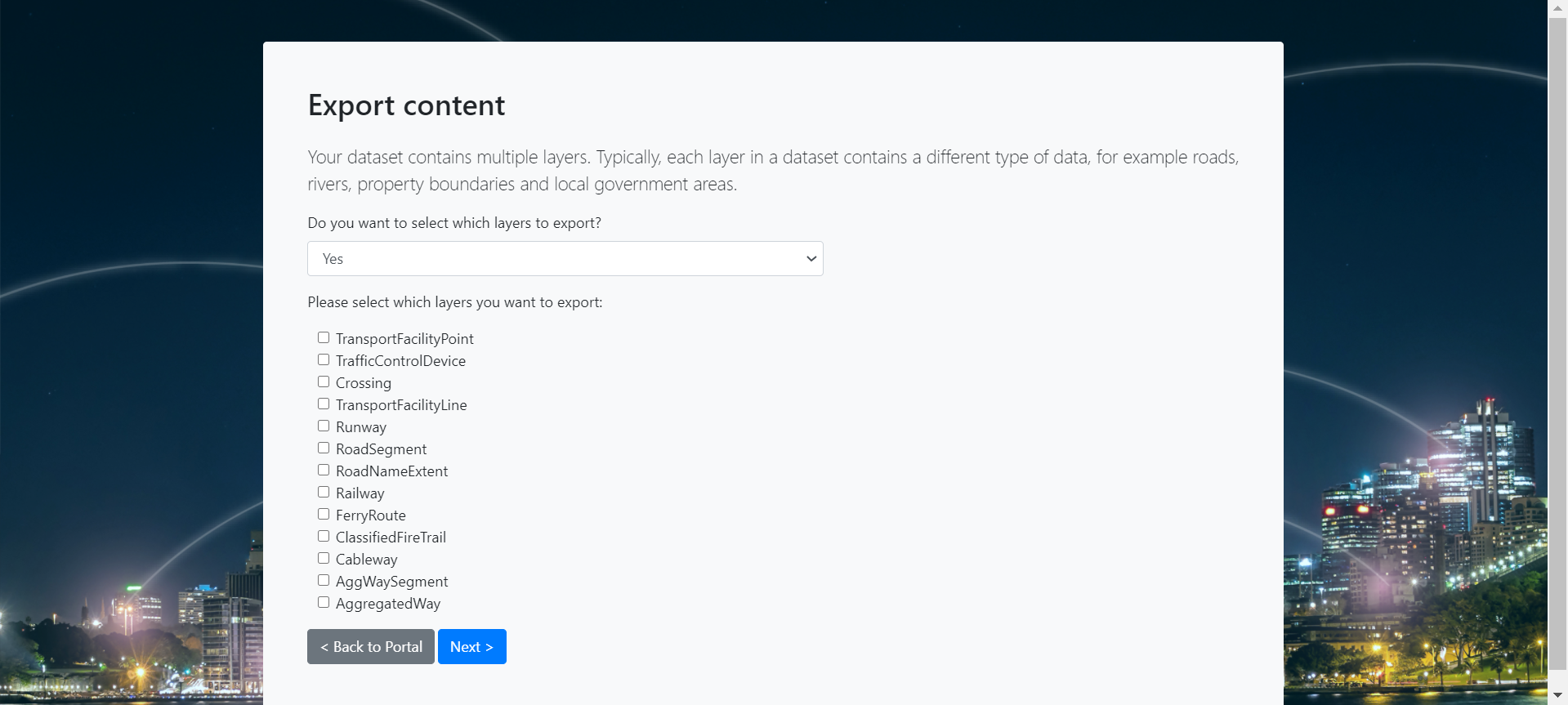 7. **Do you want to select which layers to export?** You can select *Yes* and choose from the layers provided OR you can select *No Thanks. I want to export data from all layers*. This will download all data sets. In the example below RoadNameExtent is selected. 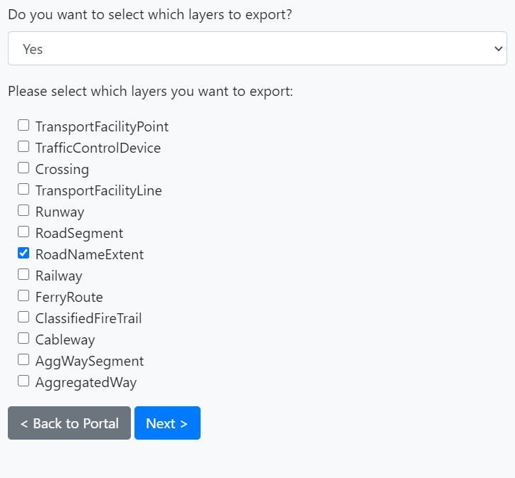 8. Click *Next* > 9. **Do you want to specify an extent**? Select No or *Yes, by drawing the extent on a map*. If you select ‘No’ all the data will be extracted. If you wanted to specify an extent of data extraction, e.g. around Sydney in the screenshot below, use the square icon labelled ‘Draw a rectangle’. This will draw a square centred on the point where you clicked on the map. You can change the shape from the icon labelled ‘Reshape’ to get the required area of extraction. 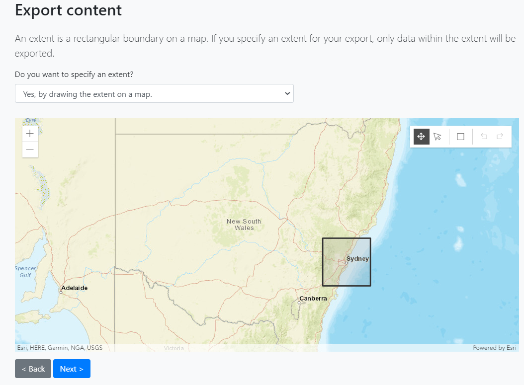 10. Click on *Next* > 11. Select your preferred Export format. Please note the limitation of ESRI Shape files truncating attribute names to 10 characters. 12. Select your preferred Export datum: Please note the current preference of GDA2020, although that depends on your objective. 13. Select your preferred Export coordinate system: ‘Geographic’ will export the geometries in latitude/longitude. MGAxx coordinate systems will export the geometries in metres. 14. Type your email address 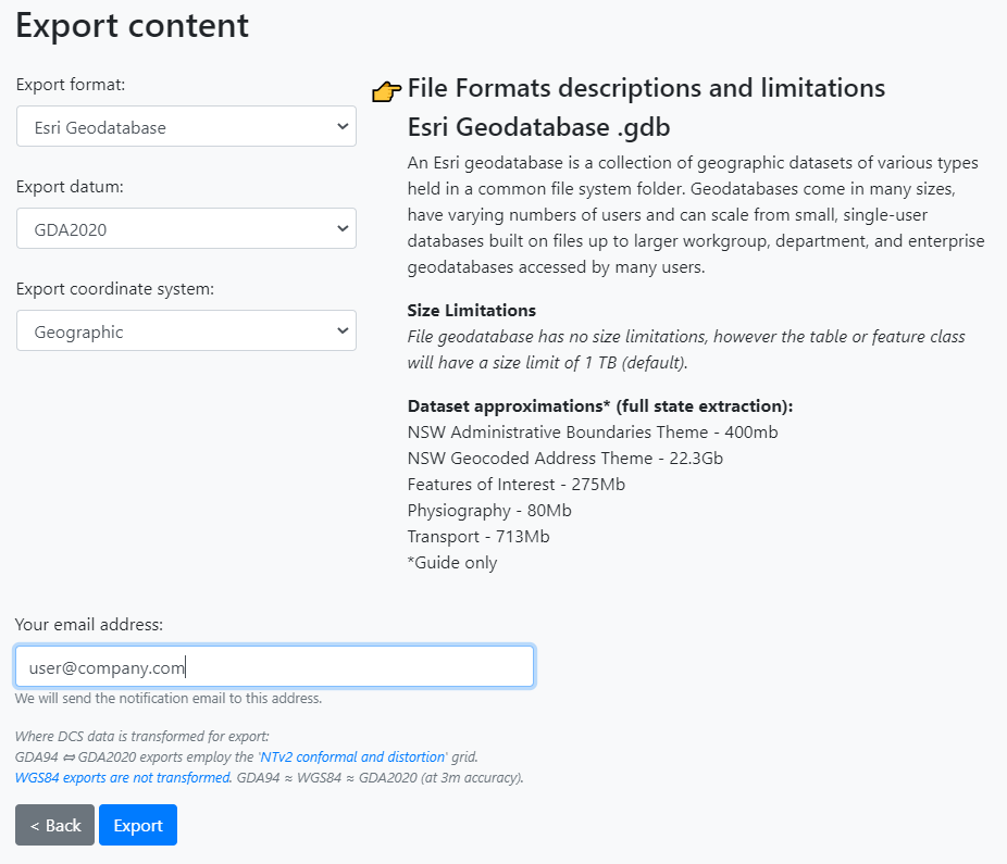 15. Click *Export* 16. You should see the screen below 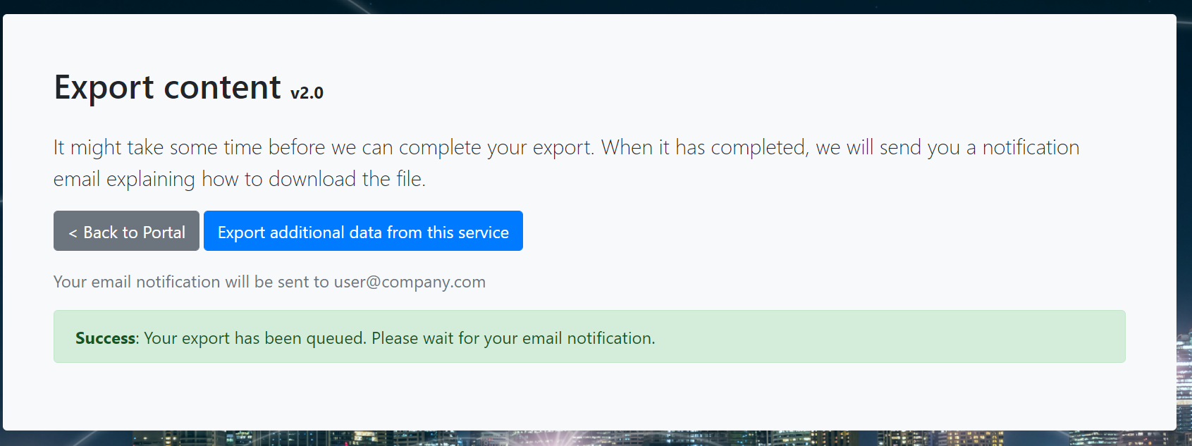 17. Check your inbox for an email from Customer Service with a link to download the data.
-
Changed the license of Road Segment Data from Data.NSW to Creative Commons Attribution (previouslyLicense Not Specified )
-
Added resource Road Segment Data from Data.NSW to Road Segment Data from Data.NSW
-
Deleted resource Road Segment Data from Data.NSW from Road Segment Data from Data.NSW